North (4,180'), Middle (4,140') and South (4,100') Tripyramid. Tony and I have been talking about these three peaks for a quite a while so we finally decided to hike them. They don't offer much in the way of views at the summit. In fact north has one view at the summit if you take a side trail, middle offers a view if you stand on a huge boulder, and south offers no view at all as it is completely tree covered. The views are climbing the rock slides to the summit, which was the plan. Unfortunately, we took the wrong trail so we were in the trees all the way to the summit of North Tripyramid. Also, South Tripyramid is not an official 4000 footer even though it sits at 4,100', but we had to hike over to it. How can you hike the "Tri"pyramids and NOT hike over to the third peak?
Trailhead sign
There is no parking lot for this trail
You have to park on the side of the Kangamangus
The start of the trail
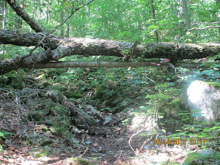
This trail was very wet and muddy, probably due to all the rain the Whites had a few days earlier. The entire loop was muddy and there were more blow downs than any other hike I have done. This trail is not well maintained, I'm guessing it's not a very popular hike except with peakbaggers.
This log was so wet and slippery I chose to not walk across it
Heading up the trail
One of many blow downs
This trail reminded me of the Flume and Liberty hike we did last year.
It was very flat for a couple of miles, then bam! The steepness hits you
View from summit or North Tripyramid
It's hard to see but the treetops were
starting to turn yellow. Winter is coming!
Mount Chocorua
from the summit of North Tripyramid
Mount Washington in the clouds
More Fall foliage coming in
Another view - I'm not sure what peaks
those are
Tony @ Summit of North Tripyramid 4,180'
Mike @ Summit of North Tripyramid 4,180'
On our way over to Middle Tripyramid
Waterville Valley Ski Area / Mount Tecumseh behind us
Summit of Middle Tripyramid 4,140'
View from summit of Middle Tripyramid
Our summit beers
Heading down from Middle over to South
Nice rock shelter
Tony @ Summit of South Tripyramid 4,100'
Massive rock slab
Another blow down
Because we took the wrong trail we didn't read about this and
it was unexpected what we were about to see
Sabbaday Falls
Sabbaday Falls
Sabbaday Falls
Sabbaday Falls
Trailhead from the other side of the loop
The loop spits you out 1 mile from the Pine Bend trailhead
So it's another 1 mile walk up the Kangamangus
to get back to the car
Not a good shot and nothing to see, but a car pulled over to let Tony and I know that a bear just crossed the road and ran into the woods at this spot.
We didn't see him
GPS Track #1
GPS Track #2
GPS Track #3
Total hike time (round trip)..: 8h 37m
Elevation Gain.....................: 3,717'
Distance (round trip)...........: 13.29m
Trails: Pine Bend Brook Trail, Mount Tripyramid Trail, Sabbaday Falls Trail


No comments:
Post a Comment